Landscape
[et_pb_section admin_label=”section” transparent_background=”off” background_color=”#afb0bc” allow_player_pause=”off” inner_shadow=”off” parallax=”off” parallax_method=”off” padding_mobile=”off” make_fullwidth=”off” use_custom_width=”off” width_unit=”on” make_equal=”off” use_custom_gutter=”off” gutter_width=”3″][et_pb_row admin_label=”row” make_fullwidth=”off” use_custom_width=”off” width_unit=”on” use_custom_gutter=”off” gutter_width=”3″ padding_mobile=”off” background_color=”#2d3250″ allow_player_pause=”off” parallax=”off” parallax_method=”off” make_equal=”off” parallax_1=”off” parallax_method_1=”off” parallax_2=”off” parallax_method_2=”off” column_padding_mobile=”on” custom_padding=”|25px||25px”][et_pb_column type=”2_3″][et_pb_image admin_label=”Featured Image” src=”http://www.bude-canal-trust.co.uk/wp-content/uploads/2015/11/img_mainLandscape.jpg” show_in_lightbox=”off” url_new_window=”off” animation=”off” sticky=”off” align=”left” force_fullwidth=”off” always_center_on_mobile=”on” use_border_color=”off” border_color=”#ffffff” border_style=”solid”]
[/et_pb_image][et_pb_text admin_label=”Main Text” background_layout=”dark” text_orientation=”left” use_border_color=”off” border_color=”#ffffff” border_style=”solid” custom_padding=”|25px||25px”]
Landscape
The Bude Canal’s Aqueduct branch has its northern end at Lower Tamar Lake, a stone’s throw to the east of where the River Tamar leaves the reservoir. From here the Aqueduct branch continues in a generally southerly direction, quite closely parallel to the Tamar and in, or on the edge of, its valley. As it continues south it describes a couple of deviations eastward to avoid small tributary valleys in order to keep to the most level course.
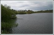 The Tamar Valley here, in its upper reaches, is not the major landscape feature that it becomes further south. Its form is more subtle, with shallow, gently sloping sides flanking its narrow, flat floor. Here and there more prominent spurs of higher land approach the river and force the valley into twists and turns.
A notable variation on the general landscape is produced by the presence of Lower Tamar Lake. Formed by the flooding of this part of the higher Tamar Valley it adds a different dimension to the character of the local landscape, although the lake’s surrounding gentle valley slopes and pastoral farmland are very much part of this landscape.
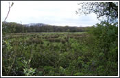 Land use in the upper Tamar Valley is primarily one of pastoral farming, with medium sized fields surrounded by boundaries formed by often substantial hedges. There is a noticeable amount of unimproved pasture, resulting in a very traditional appearance created by the natural vegetation, which is known as culm grassland. As described in the wildlife section, this landscape is important for wildlife on a national basis, and the Aqueduct branch passes through a National Nature Reserve at Dunsdon and a Devon Wildlife Trust reserve at Vealand.
The underlying geology, the culm measures, do not give rise to a very fertile soil – hence the need in the 19th century to add lime-rich sea sand brought from the coast by the Canal. Consequently in the relatively recent past this has resulted in the establishment 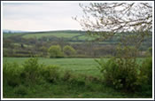 of coniferous woodland plantations in a number of places in the upper Tamar Valley in an attempt to make an economic return on the land. Some such plantations may be seen adjacent to the Aqueduct branch. One fairly sizeable plantation has recently been felled to be replaced by culm grassland. Another is at the junction of the Holsworthy Branch between Brendon and Vealand Bridges.
The quiet and remote nature of the landscape is a major factor in the landscape character of this area. In 1995 the then Countryside Commission, in conjunction with the Council for the Protection of Rural England (CPRE), undertook a study of the so-called “Tranquil Areas” of England. The study used certain set criteria to define “Tranquil Areas”, including distance from power stations, from heavily trafficked roads and railways, large and medium sized towns and industrial areas. This exercise was repeated by the CPRE in the early 2000s. The maps produced by these studies indicated that the largest Tranquil Area in southern England included the northern part of the Devon-Cornwall border, with the upper Tamar Valley, and thus the Bude Canal Aqueduct, near its heart.
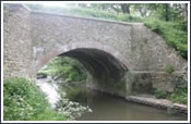 Travelling the length of the Aqueduct, the experience is one of a remote rural area, pastoral, the fields bounded by substantial hedges and with occasional views of coniferous woodland plantations. The countryside rolls generally down to the Tamar to the west, the opposite side of the Tamar Valley forming a relatively close visibility limit. Here and there are seen farm buildings. Trees and hedges line the canal itself. Near the northern end is the old canal wharf and canal building at Virworthy, while towards the southern end is the inclined plane at Vealand and, just beyond, the aqueduct bridge over the Tamar.
At present, the public footpath ends at the Tamar though the Trust’s land continues with the canal and a permissive footpath for almost another 700 yards on the Cornwall side of the river through a similar landscape to that on the Devon side and further north, described above.
[/et_pb_text][/et_pb_column][et_pb_column type=”1_3″][et_pb_text admin_label=”Text Links” background_layout=”dark” text_orientation=”left” text_font_size=”14″ use_border_color=”off” border_color=”#ffffff” border_style=”solid” custom_padding=”5px|5px|5px|5px” background_color=”#585969″]
Wildlife & Landscape
[/et_pb_text][et_pb_blurb admin_label=”Link with image” title=”Trust Contacts” url_new_window=”off” use_icon=”off” icon_color=”#7EBEC5″ use_circle=”off” circle_color=”#7EBEC5″ use_circle_border=”off” circle_border_color=”#7EBEC5″ icon_placement=”top” animation=”off” background_layout=”dark” text_orientation=”left” use_icon_font_size=”off” background_color=”#585969″ use_border_color=”off” border_color=”#ffffff” border_style=”solid” custom_padding=”5px|5px|5px|5px” image=”http://www.bude-canal-trust.co.uk/wp-content/uploads/2015/11/subimg_contacts.jpg” url=”http://www.bude-canal-trust.co.uk/trust-contacts/”]
Or email us on enquiries@bude-canal-trust.co.uk
[/et_pb_blurb][/et_pb_column][/et_pb_row][/et_pb_section]